• Home
  • Events
    • LAC 2014, Rome
    • Mérida/CIAC 2013
    • Perth/CAA 2013
    • People Conference – November 2012
    • Limassol/Lemesos Conference – October 2012
    • Seville Congress – June 2012
    • Book launch
    • Leuven Symposium, 2012
    • Berlin – Conference, June 2012
    • Frankfurt Conference, March 2012
    • Southampton Conference, March 2012
    • Brussels Innovation Convention, December 2011
    • Vienna Conference, November 2011
    • Copenhagen Conference, September 2011
  • Training
    • Summer School
    • 3rd Specialization Forum
      • Report on the 3rd Specialization Forum
    • 1st MAC Workshop of Archaeological Geophysics
    • Aerial Archaeology Training School
    • 2nd Specialization Forum
    • 1st Specialization Forum
    • Posts
  • Radio-Past
    • Project details
    • Research techniques
      • Airborne remote sensing
        • Traditional aerial imaging
        • Helikites and drones
        • NUV and NIR photography
        • LiDAR
      • Field survey
      • Geophysical survey
        • Earth resistance
        • Georadar
        • Magnetometer
        • Susceptibility
      • Topographical and geomorphological survey
        • Geomorphology
      • Groundtruthing
      • Virtual reconstruction
    • Partners
    • Reference projects
  • Publications
    • Booklet + dvd
    • Ammaia I
    • Ghent Colloquium
  • Open Lab Ammaia
    • Recent activities
      • 2010 Campaign
      • Book launch / Lisbon
    • Job opportunities
    • History
    • Recent research
      • Aerial survey
        • Aerial photography
        • LiDAR
      • Surface artefact collection
      • Geo-archaeological survey
        • Gold mining
        • Stone quarries
        • Rural landscape
      • Geophysical survey
        • Earth resistance
        • Georadar
        • Magnetometer
        • Magnetic susceptibility
      • Topographical survey
        • Reference system
        • Digital elevation model
      • Field survey
      • Architectural scanning
      • Excavation
        • Trial trenching
        • Thermae excavations
      • Material studies
        • Artefact study
        • Laboratory analyses
      • Virtual reconstruction
    • Mapping the city
    • Archaeological park and museum
    • Bibliography
  • Multimedia
    • 3D-reconstructions
      • Renderings
      • Reconstructions
    • Maps and plans
    • Movies
      • EAIE Conference
      • RTP Report 2
    • Panoramic images
    • Photographs
      • Snow in Ammaia!
  • Links
  • Site map
  • Contact
  • Login
Browse: Home / Multimedia / 3D-reconstructions

3D-reconstructions

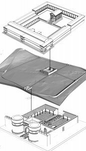
The visualization of the geophysical results are approached by referencing the existing data with better preserved sites of the region comparing similar structures and dimensions, aiming to preserve architectural local features and details of decoration.


First attempt to reconstruct the forum and the Porta Sul of Ammaia (illustration by M. Klein)

First attempt to reconstruct the forum and the Porta Sul of Ammaia (illustration by M. Klein)

Digital Elevation models, geophysic results, 3d Laser and Lidar -scans are taken into account to build the ancient terrain, where the results of the architectural 3d reconstruction will reside.

Special programs are used to achieve realistic results and breathe live into the scenes . A motioncapture system is used to drive the animation of computer generated people to ensure correct movements while keeping the production costs feasible . Sophisticated render algorithms will enable the creation of thousands of terrain features, like plants, stones and boulders as well as populating the scenes with animated characters.


The output will result in a short movie clip (approx. 15Min) which can be also used for ongoing productions for television (documentaries) and print publications, with the option to re/use the produced data for other medias like installations for augmented reality, 3d realtime applications (educati

onal games) and VR environments (Dome or Cave -Projections).
Leave a Reply

Click here to cancel reply.

You must be logged in to post a comment.

Search

News


3rd International Landscape Archaeology Conference


A Romano-Lusitanian townscape revealed

Copyright © 2016 Radio-Past.

Powered by WordPress and Hybrid. Operated by 7reasons