• Home
  • Events
    • LAC 2014, Rome
    • Mérida/CIAC 2013
    • Perth/CAA 2013
    • People Conference – November 2012
    • Limassol/Lemesos Conference – October 2012
    • Seville Congress – June 2012
    • Book launch
    • Leuven Symposium, 2012
    • Berlin – Conference, June 2012
    • Frankfurt Conference, March 2012
    • Southampton Conference, March 2012
    • Brussels Innovation Convention, December 2011
    • Vienna Conference, November 2011
    • Copenhagen Conference, September 2011
  • Training
    • Summer School
    • 3rd Specialization Forum
      • Report on the 3rd Specialization Forum
    • 1st MAC Workshop of Archaeological Geophysics
    • Aerial Archaeology Training School
    • 2nd Specialization Forum
    • 1st Specialization Forum
    • Posts
  • Radio-Past
    • Project details
    • Research techniques
      • Airborne remote sensing
        • Traditional aerial imaging
        • Helikites and drones
        • NUV and NIR photography
        • LiDAR
      • Field survey
      • Geophysical survey
        • Earth resistance
        • Georadar
        • Magnetometer
        • Susceptibility
      • Topographical and geomorphological survey
        • Geomorphology
      • Groundtruthing
      • Virtual reconstruction
    • Partners
    • Reference projects
  • Publications
    • Booklet + dvd
    • Ammaia I
    • Ghent Colloquium
  • Open Lab Ammaia
    • Recent activities
      • 2010 Campaign
      • Book launch / Lisbon
    • Job opportunities
    • History
    • Recent research
      • Aerial survey
        • Aerial photography
        • LiDAR
      • Surface artefact collection
      • Geo-archaeological survey
        • Gold mining
        • Stone quarries
        • Rural landscape
      • Geophysical survey
        • Earth resistance
        • Georadar
        • Magnetometer
        • Magnetic susceptibility
      • Topographical survey
        • Reference system
        • Digital elevation model
      • Field survey
      • Architectural scanning
      • Excavation
        • Trial trenching
        • Thermae excavations
      • Material studies
        • Artefact study
        • Laboratory analyses
      • Virtual reconstruction
    • Mapping the city
    • Archaeological park and museum
    • Bibliography
  • Multimedia
    • 3D-reconstructions
      • Renderings
      • Reconstructions
    • Maps and plans
    • Movies
      • EAIE Conference
      • RTP Report 2
    • Panoramic images
    • Photographs
      • Snow in Ammaia!
  • Links
  • Site map
  • Contact
  • Login
Browse: Home / Radio-Past / Research techniques / Airborne remote sensing / Traditional aerial imaging

Traditional aerial imaging

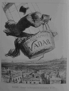
Caption: Nadar élevant la Photographie à la hauteur de l'Art" (Nadar elevating Photography to Art). Lithograph by Honore Daumier, appearing in Le Boulevard, May 25, 1863. (Honoré Daumier, DR 3248 copyright: www.daumier-register.org)

Caption: Nadar élevant la Photographie à la hauteur de l'Art" (Nadar elevating Photography to Art). Lithograph by Honore Daumier, appearing in Le Boulevard, May 25, 1863. (Honoré Daumier, DR 3248 copyright: www.daumier-register.org)

The use of aerial photography for archaeological research is almost as old as the invention of photography and systems to fly. The first images to be used for the comprehension of archaeological evidence were in fact already taken by the famous master of photography Gaspard-Félix Tournachon, better known as Nadar, and pioneering applications were already developed by Giacomo Boni on the Forum Romanum. Innumerable examples of archaeological discoveries could be mentioned for the 1910’s, 1920’s and 1930’s (unforgettable are the first discoveries of the Roman Land division systems in Northern Africa by Charles Saumagne and others).

Aerial photography and stereoscopy applications got an impressive impulse during the second World War, when many thousands of vertical aerial pictures were taken for “espionage” and mapping of war field purposes. Since then aerial photography has developed as an intrinsic part of archaeological survey. The systematic use in archaeology of vertical photographs, often not taken for archaeological purposes, has revealed itself crucial for the detection and mapping of traces and ancient landscapes. Active aerial photography, often taken from lower altitude and with an oblique camera position, became more and more widespread in Europe since the 1960’s. The development and democratization of colour photography and later of digital photography, together with the cost efficiency of the technique, stimulated its role in landscape archaeology today.

Leave a Reply

Click here to cancel reply.

You must be logged in to post a comment.

Search

News


3rd International Landscape Archaeology Conference


A Romano-Lusitanian townscape revealed

Copyright © 2016 Radio-Past.

Powered by WordPress and Hybrid. Operated by 7reasons