• Home
  • Events
    • LAC 2014, Rome
    • Mérida/CIAC 2013
    • Perth/CAA 2013
    • People Conference – November 2012
    • Limassol/Lemesos Conference – October 2012
    • Seville Congress – June 2012
    • Book launch
    • Leuven Symposium, 2012
    • Berlin – Conference, June 2012
    • Frankfurt Conference, March 2012
    • Southampton Conference, March 2012
    • Brussels Innovation Convention, December 2011
    • Vienna Conference, November 2011
    • Copenhagen Conference, September 2011
  • Training
    • Summer School
    • 3rd Specialization Forum
      • Report on the 3rd Specialization Forum
    • 1st MAC Workshop of Archaeological Geophysics
    • Aerial Archaeology Training School
    • 2nd Specialization Forum
    • 1st Specialization Forum
    • Posts
  • Radio-Past
    • Project details
    • Research techniques
      • Airborne remote sensing
        • Traditional aerial imaging
        • Helikites and drones
        • NUV and NIR photography
        • LiDAR
      • Field survey
      • Geophysical survey
        • Earth resistance
        • Georadar
        • Magnetometer
        • Susceptibility
      • Topographical and geomorphological survey
        • Geomorphology
      • Groundtruthing
      • Virtual reconstruction
    • Partners
    • Reference projects
  • Publications
    • Booklet + dvd
    • Ammaia I
    • Ghent Colloquium
  • Open Lab Ammaia
    • Recent activities
      • 2010 Campaign
      • Book launch / Lisbon
    • Job opportunities
    • History
    • Recent research
      • Aerial survey
        • Aerial photography
        • LiDAR
      • Surface artefact collection
      • Geo-archaeological survey
        • Gold mining
        • Stone quarries
        • Rural landscape
      • Geophysical survey
        • Earth resistance
        • Georadar
        • Magnetometer
        • Magnetic susceptibility
      • Topographical survey
        • Reference system
        • Digital elevation model
      • Field survey
      • Architectural scanning
      • Excavation
        • Trial trenching
        • Thermae excavations
      • Material studies
        • Artefact study
        • Laboratory analyses
      • Virtual reconstruction
    • Mapping the city
    • Archaeological park and museum
    • Bibliography
  • Multimedia
    • 3D-reconstructions
      • Renderings
      • Reconstructions
    • Maps and plans
    • Movies
      • EAIE Conference
      • RTP Report 2
    • Panoramic images
    • Photographs
      • Snow in Ammaia!
  • Links
  • Site map
  • Contact
  • Login
Browse: Home / Open Lab Ammaia / Mapping the city

Mapping the city

Under this heading we intend to show the progress of the Radio-Past project on mapping the town of Ammaia using the techniques explained in the previous section. Starting from the hypothetical scheme of the town location and structure, derived from earlier geo-archaeological surveys on the site and from the excavations in four areas since 1994, the new work should be able to arrive at a “total” mapping of all significant excavated and especially non-excavated remains of the Roman town.

Hypothetical plan of the city of Ammaia with its main features as deduced from earlier fieldwork
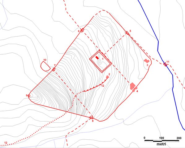
Hypothetical plan of the city of Ammaia with its main features as deduced from earlier fieldwork and and aerial photography interpretation. Main features: 1. forum, 2. baths, 3. house complex, 4.-8. gates, 9. tower, 10. theatre, 11. bridge, 12. aqueduct

Located and partly reconstructed trace of the western Roman aqueduct of Ammaia (illustration by S. Deprez)
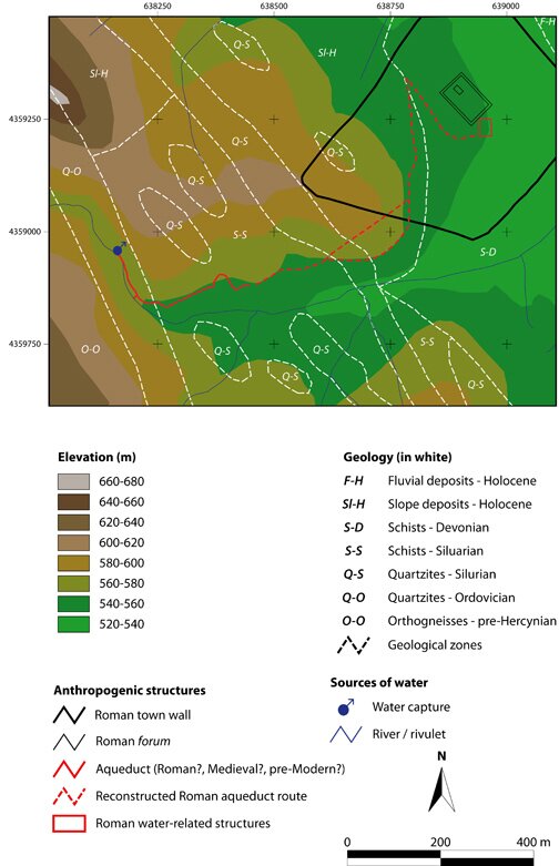
Located and partly reconstructed trace of the western Roman aqueduct of Ammaia (by S. Deprez)

Search

News


3rd International Landscape Archaeology Conference


A Romano-Lusitanian townscape revealed

Copyright © 2016 Radio-Past.

Powered by WordPress and Hybrid. Operated by 7reasons