Analogue Near-InfraRed (NIR) photography has already been used a lot in both scientific and medical photography, in which cases NIR radiation was mostly captured by InfraRed (IR) sensitive plates or film emulsions. However, its use in archaeology has remained rather restricted, most likely due to some ignorance and/or lack of knowledge about this kind of photography, while the critical imaging process also severely limited its use. This situation could be, however, changed completely, as the silicon image sensors used in Digital Still Cameras (DSCs) are very sensitive to NIR wavelengths, making the quite lengthy and error-prone film-based NIR imaging process obsolete. As most common silicon sensors are also inherently sensitive to Near-UltraViolet (NUV) energy, both invisible ranges of radiation can be explored in aerial archaeology.
Invisible radiation
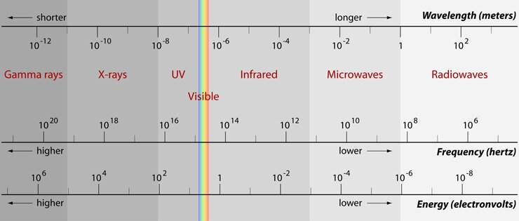
The light that makes the Human Visual System (HVS) perceive the world around us is in fact an EM wave, comprising two oscillating electric and magnetic fields perpendicular to each other as well as perpendicular to the direction of propagation. The EM waves humans perceive – the so-called visible light – encompasses only a very small portion of all EM radiation: only wavelengths between approximately 400 nm and 700/750 nm. On both sides of this extremely small visible spectrum resides EM radiation the HVS is insensitive for, characterised by wavelengths smaller than 400 nm or larger than 750 nm. The aforementioned NIR portion of the EM spectrum comprises wavelengths between 750 nm and 1400 nm (1.4 mm), whereas the NUV region (also called the UV-A or Long Wave UV) ranges from 315 nm till 400 nm.
 The electromagnetic spectrum (illustration by G. Verhoeven)
Imaging
Both kinds of invisible radiation are generated by the Sun. A portion of the incident energy is reflected from the earth’s surface. To capture this reflected NUV and NIR by digital means, an off-the-shelf digital DSC can be modified. When buying such a digital piece of equipment, its imaging sensor is covered with an NUV-NIR cut-off filter that allows only visible light to pass. By implementing this filter, the camera manufacturer ensures that the sensor’s array of photosensitive detectors – called photodiodes – will generate a photographic signal by mainly taking the visible radiation into account. This approach is of the utmost importance, as the image contribution of both NUV and NIR wavelengths would be very detrimental for image sharpness (all wavelengths have a different focus), exposure accuracy (DSC light meters are not calibrated for invisible radiation), and true colour reproduction (human perception normally does not take this radiation into account).
Removing this internal filter makes the digital camera sensitive from the NUV range to the NIR radiation (approximately 350 nm to 1000 nm). Because the spectral response of common silicon detectors found in the current DSCs decreases quite rapidly towards shorter wavelengths (i.e. NUV), the modification is most noticeable when imaging the NIR waveband. Using the correct array of filters (placed in front of the sensor inside the camera or fitted to the lens), it becomes possible to image only the NUV or NIR part of the whole EM spectrum. By using this invisible radiation, digital NUV and NIR photography tries to make certain archaeological marks (more) distinct, because the reflection of plants and soils differs in most circumstances a big deal from the characteristic visible reflectance properties.


