Since the beginning of aerial photography, researchers have used all kinds of devices ranging from pigeons, kites, poles, and balloons to rockets in order to take cameras aloft and remotely gather aerial data needed for a combination of research goals. To date, many of these unmanned devices are still used, mainly to gather archaeologically relevant information from relatively low altitudes, enabling so-called low-altitude aerial photography (LAAP). In the Radio-Past Project, two LAAP devices are used: a Helikite and a Microdrone.
Helikite
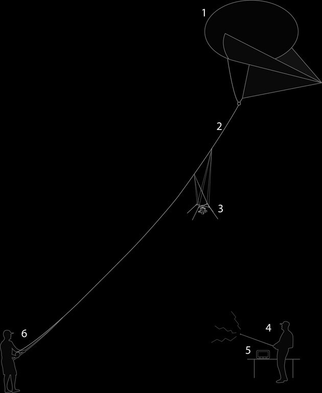
The Helikite is a hybrid between a balloon and a kite patented in 1993. By combining a helium balloon with kite wings (1 in the figure), this lighter-than-air device combines the best properties of both platforms without incurring too much of their disadvantages. The helium filled balloon allows the Helikite to take off in windless weather conditions, whereas the kite components become important in case there is wind, as they counteract any unstable behaviour that is characteristic of traditional balloons and blimps flown in windy conditions. Moreover, the construction supports more payload for its size when compared with ordinary aerostats.
 Helikite aerial photography (illustration by G. Verhoeven)
Underneath the tethered Helikite (2), a construction is mounted that holds a normal, Near-InfraRed (NIR) or Near-UltraViolet (NUV) enabled digital reflex camera (3). Both this construction and the camera can be Radio-Controlled (R/C) from the ground (4). This way, the Helikite makes it possible to capture remote imagery from a variety of altitudes and angles. Orienting the camera is guided by a miniature movie camera that looks directly through the camera’s eyepiece. As the video signal is transmitted wirelessly to a ground-based monitor (5), there exists a real-time feed-back about the ground coverage of the digital camera. The Helikite itself is positioned using a fishing reel and rod: this allows to manage the tractive forces of the device and enable the Helikite’s operator (i.e. the ‘navigator’) to freely walk around while letting out tether smoothly and quickly (6).
Although this Helikite Aerial Photography (or HAP) has been successful during several archaeological campaign, it has one large drawback: the direction it flows is largely wind dependent. Consequently, it remains rather challenging to accurately establish a precise camera location and/or take photographs along a previously outlined track.To tackle this issue, it is planned to buy a Microdrone.
Microdrone
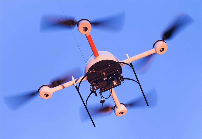
Initially developed for purely military applications, drones or Unmanned Aerial Vehicles or UAVs are powered aerial vehicles that do not take a human operator aloft but fly and manoeuvre in the air autonomously or completely remotely controlled. In the near future, it is hoped to acquire such a drone: the Microdrone md4-1000, a quadrotor with D-GPS positioning. Using four rotors, this drone should be capable of lifting a digital reflex camera, while its GPS provides autonomous waypoint navigation and position hold (to take an aerial photograph).
 Microdrone (image copyright of Microdrones.GmbH)


