• Home
  • Events
    • LAC 2014, Rome
    • Mérida/CIAC 2013
    • Perth/CAA 2013
    • People Conference – November 2012
    • Limassol/Lemesos Conference – October 2012
    • Seville Congress – June 2012
    • Book launch
    • Leuven Symposium, 2012
    • Berlin – Conference, June 2012
    • Frankfurt Conference, March 2012
    • Southampton Conference, March 2012
    • Brussels Innovation Convention, December 2011
    • Vienna Conference, November 2011
    • Copenhagen Conference, September 2011
  • Training
    • Summer School
    • 3rd Specialization Forum
      • Report on the 3rd Specialization Forum
    • 1st MAC Workshop of Archaeological Geophysics
    • Aerial Archaeology Training School
    • 2nd Specialization Forum
    • 1st Specialization Forum
    • Posts
  • Radio-Past
    • Project details
    • Research techniques
      • Airborne remote sensing
        • Traditional aerial imaging
        • Helikites and drones
        • NUV and NIR photography
        • LiDAR
      • Field survey
      • Geophysical survey
        • Earth resistance
        • Georadar
        • Magnetometer
        • Susceptibility
      • Topographical and geomorphological survey
        • Geomorphology
      • Groundtruthing
      • Virtual reconstruction
    • Partners
    • Reference projects
  • Publications
    • Booklet + dvd
    • Ammaia I
    • Ghent Colloquium
  • Open Lab Ammaia
    • Recent activities
      • 2010 Campaign
      • Book launch / Lisbon
    • Job opportunities
    • History
    • Recent research
      • Aerial survey
        • Aerial photography
        • LiDAR
      • Surface artefact collection
      • Geo-archaeological survey
        • Gold mining
        • Stone quarries
        • Rural landscape
      • Geophysical survey
        • Earth resistance
        • Georadar
        • Magnetometer
        • Magnetic susceptibility
      • Topographical survey
        • Reference system
        • Digital elevation model
      • Field survey
      • Architectural scanning
      • Excavation
        • Trial trenching
        • Thermae excavations
      • Material studies
        • Artefact study
        • Laboratory analyses
      • Virtual reconstruction
    • Mapping the city
    • Archaeological park and museum
    • Bibliography
  • Multimedia
    • 3D-reconstructions
      • Renderings
      • Reconstructions
    • Maps and plans
    • Movies
      • EAIE Conference
      • RTP Report 2
    • Panoramic images
    • Photographs
      • Snow in Ammaia!
  • Links
  • Site map
  • Contact
  • Login
Browse: Home / Radio-Past / Research techniques

Research techniques

To a large extent scientific research and heritage-management of buried archaeological sites aim to limit destructive intervention, such as excavation, to the absolute minimum. This often results in a kind of passive protection of thousands of European sites, which however remain only partially located, badly understood and unknown in their complexity. During the last two decades a set of methods of surface survey and non-invasive sub-surface prospection have been developed, in a way that these sites can now be analysed, interpreted and eventually visualised without any damage to the monuments themselves. This is particularly relevant for larger and complex sites with sometimes well preserved sub-surface structural remains, such as a whole range of proto-urban and urban settlements of ancient Europe. Within the Radio-Past project we focus on one particular type of complex urban sites: the abandoned Roman city. This type of site, of which hundreds have been located throughout Europe and beyond, generally has a wide range of well preserved archaeological structures in its subsoil, offering researchers a firm base for intensive non-destructive surveys.
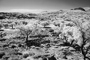
Pure NIR photography of the Roman quarry site of Pitaranha (photograph by G. Verhoeven)Pure NIR photography of the Roman quarry site of Pitaranha (photograph by G. Verhoeven)

Such deserted archaeological sites can now be well studied and efficiently protected using an integrated set of modern survey techniques, such as airborne remote sensing, field or artefact survey, ground-based geophysical survey, topographical and geomorphologic surveys, field checks, and virtual reconstructions.

Search

News


3rd International Landscape Archaeology Conference


A Romano-Lusitanian townscape revealed

Copyright © 2016 Radio-Past.

Powered by WordPress and Hybrid. Operated by 7reasons